Nature’s Ancient Sanctuary: The Resilient Floodplains of Congaree National Park
Nestled in South Carolina, Congaree National Park stands as a unique ecological marvel, defined almost entirely by the movement of a single river. Unlike most other national preserves, a striking 80 percent of Congaree’s land lies directly within the active floodplain of the Congaree River. This dynamic environment has allowed the park to foster and protect one of the largest remaining intact tracts of old-growth bottomland hardwood forests in the United States.
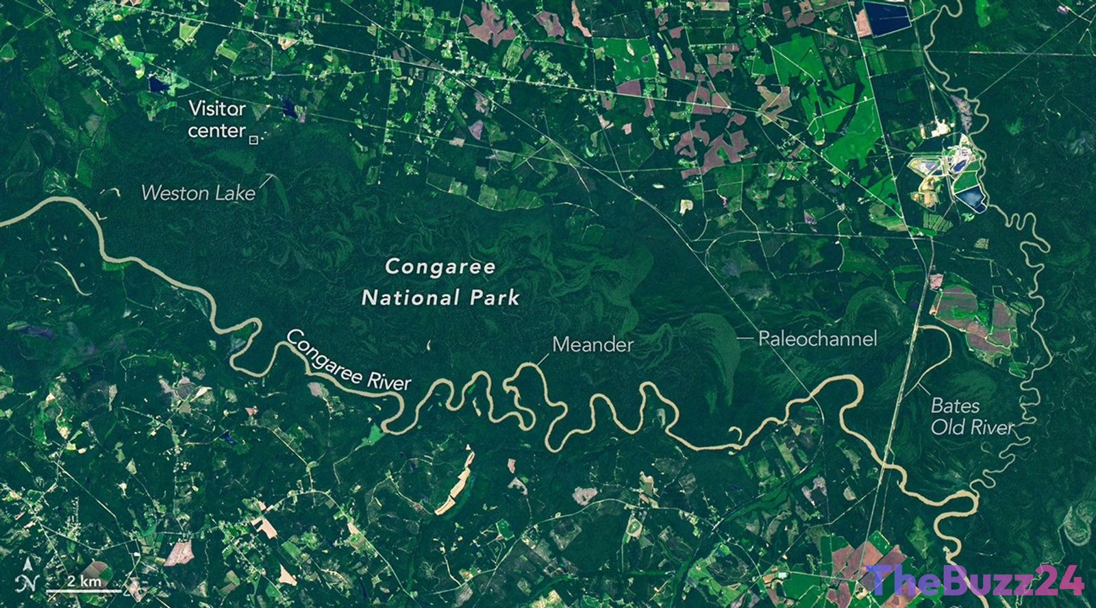
Satellite observations, including those from Landsat 9, reveal a complex landscape where the river snakes through flat, soft terrain. This geography encourages the formation of dramatic bends and meanders. As water flows faster along the outer edges of these curves, it carves into the banks, while slower-moving water on the inside deposits sediment to form sandy point bars. Over time, these shifting pathways cut off river bends entirely, creating U-shaped oxbow lakes such as Weston Lake and the four-mile-long Bates Old River. These abandoned channels gradually fill with sediment, transforming into shallow wetlands and sloughs where water-tolerant cypress-tupelo forests thrive.
The survival of this ancient forest is a historical anomaly. While commercial loggers aggressively targeted the region’s timber in the 1880s, the formidable natural defenses of the Congaree floodplain—including relentless seasonal flooding, impassable mud, and dense mosquito populations—made large-scale logging nearly impossible. Recognizing the rare beauty of this untouched ecosystem, conservationists rallied to protect the area, leading to its designation as a national monument in 1976 and its eventual elevation to a national park in 2003.
Today, the park’s health remains deeply tied to its seasonal cycles. Multiple times a year, heavy rains and storms cause the Congaree River to overflow, spreading nutrient-rich silt across the forest floor. This natural fertilization process supports an astonishing array of giant “champion” trees. Over the decades, species such as the loblolly pine, sweetgum, and swamp tupelo within the park have repeatedly set national and state size records, securing Congaree’s reputation as a sanctuary for some of the tallest canopy trees in eastern North America.
Key Takeaways
- Congaree National Park contains one of the largest intact tracts of old-growth bottomland hardwood forests remaining in the United States, with 80 percent of the park situated in a floodplain.
- The park's unique geological features, including oxbow lakes and sloughs, are continuously shaped by the meandering path of the Congaree River.
- Harsh environmental conditions historically protected the forest from 19th-century logging, allowing massive 'champion' trees to grow to record-breaking heights.
Editor’s Analysis & Impact
Congaree National Park serves as a critical case study in the value of wetland preservation and natural flood management. As climate change drives more volatile weather patterns and intense storms, intact floodplains like Congaree play an indispensable role in absorbing excess water and mitigating downstream flood damage. Furthermore, these old-growth forests act as highly efficient carbon sinks, making their preservation vital for regional climate resilience. However, the park’s future depends heavily on upstream water management and urban development along the Congaree River. To maintain this delicate hydrological balance, environmental policymakers must prioritize watershed-wide conservation strategies that prevent pollution and maintain natural flow regimes, ensuring this ancient ecosystem continues to thrive for generations to come.
Frequently Asked Questions
Q: Why is the floodplain so important to Congaree National Park?
A: The floodplain covers 80 percent of the park and regularly deposits nutrient-rich silt during seasonal floods. This natural fertilization process nourishes the soil, allowing the park's famous 'champion' trees to grow to extraordinary heights.
Q: How did Congaree's old-growth forest survive the logging boom of the 1800s?
A: The area's challenging terrain—characterized by frequent flooding, deep mud, and heavy mosquito populations—made timber extraction highly impractical for 19th-century loggers, leaving the forest largely untouched.
Q: What is an oxbow lake, and are there examples in the park?
A: An oxbow lake is a U-shaped lake formed when a wide meander of a river is cut off to create a free-standing body of water. Congaree National Park features several prominent examples, including Weston Lake and Bates Old River.
AI Disclosure: This article is based on verified data and official reports. Our Team and AI have cross-referenced every financial detail with primary sources to ensure total accuracy.
More from this Category