Cultivating the Delta: How Manitoba’s Northernmost Farmland Defies the Wetlands
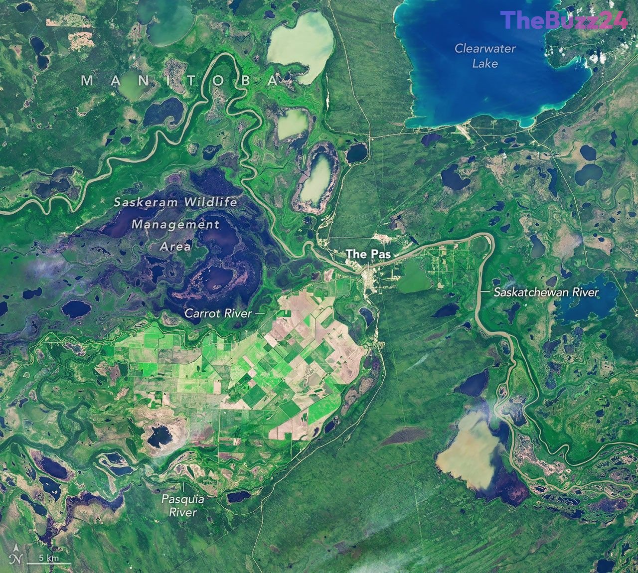
Nestled within the winding channels, marshes, and lakes of the Saskatchewan River Delta lies a striking anomaly: a highly structured, geometric grid of agricultural fields. Located west of the town of The Pas, this region is known as the Carrot River Valley, or the Pasquia Area Settlement. Spanning more than 40,000 hectares (100,000 acres) within the Rural Municipality of Kelsey, this fertile pocket represents Manitoba’s northernmost farming district, standing out as a dry agricultural haven surrounded by the sprawling wetlands of the Saskeram Wildlife Management Area.
Recent satellite observations from the Landsat 8 and Landsat 9 missions captured the dramatic transformation of this unique landscape during the 2026 growing season. In early July, the valley glowed with lush green crops, showcasing rapid vegetative growth. By late September, the landscape transitioned to golden and brown hues as harvesting got underway. Historically, the region’s crop inventory has been dominated by canola and spring wheat, with occasional smaller plantings of specialty crops like Canary seed.
Farming at this northern latitude presents a unique set of environmental opportunities and challenges. The 2026 season began with wet spring conditions that delayed initial planting compared to southern regions. However, the combination of highly fertile soils and extended daylight hours during the peak of the northern summer allowed crops to catch up rapidly. By autumn, localized weather patterns played a critical role in harvest progress; while surrounding areas faced rain delays, a dry spell in The Pas allowed local farmers to make significant headway on their wheat and canola yields.
Maintaining agricultural productivity in the heart of an active river delta requires constant vigilance and engineering. Much of the surrounding delta is naturally too wet for traditional farming. To overcome this, a massive flood control and drainage initiative was launched in the 1950s. Today, the survival of the Carrot River Valley’s agricultural sector remains entirely dependent on a continuous network of dikes and active pumping systems designed to keep the surrounding waters at bay.
Key Takeaways
- The Carrot River Valley is Manitoba's northernmost agricultural zone, spanning 40,000 hectares of managed farmland surrounded by the wet Saskatchewan River Delta.
- Despite wet spring delays, the region's fertile soil and long summer daylight hours enable rapid crop maturation for primary yields of canola and spring wheat.
- The ongoing viability of this agricultural 'island' relies on a mid-century network of dikes and pumps to prevent flooding from surrounding wetlands.
Editor’s Analysis & Impact
The agricultural success of the Carrot River Valley highlights the growing importance of northern farming frontiers as global climate patterns shift. While high-latitude regions offer fertile soils and extended summer daylight, they remain highly vulnerable to extreme weather and waterlogging. The reliance on mid-century drainage infrastructure underscores a critical vulnerability: as climate change increases the frequency of intense weather events, these aging flood-control systems will require significant modernization. Furthermore, the integration of satellite monitoring, such as the Landsat program, is becoming indispensable for modern agribusiness. Real-time crop inventories and soil moisture tracking allow policymakers and farmers to optimize supply chains and adapt to volatile harvesting windows, securing food production in historically marginal environments.
Frequently Asked Questions
Q: What crops are primarily grown in the Carrot River Valley?
A: Farmers in this region predominantly cultivate canola and spring wheat, alongside smaller yields of specialty crops like Canary seed.
Q: How do farmers manage the high risk of flooding in this delta region?
A: Agriculture in the valley is made possible by a comprehensive water management system initiated in the 1950s, which utilizes dikes and active pumping stations to protect fields from surrounding wetlands.
Q: Why does crop growth accelerate in this northern location despite late planting?
A: Although wet spring conditions often delay planting, the region benefits from highly fertile soils and significantly longer daylight hours during the summer peak, which helps crops mature rapidly.
AI Disclosure: This article is based on verified data and official reports. Our Team and AI have cross-referenced every financial detail with primary sources to ensure total accuracy.
More from this Category