Massive Wildfires Choke Oregon as Satellite Imagery Captures Devastating Scale
A relentless series of wildfires continues to ravage Oregon, scorching over a million acres and blanketing the region in a dense, hazardous haze. The crisis began when a wave of dry thunderstorms swept across the Cascade Range, unleashing thousands of lightning strikes that ignited numerous blazes throughout central and eastern sections of the state.
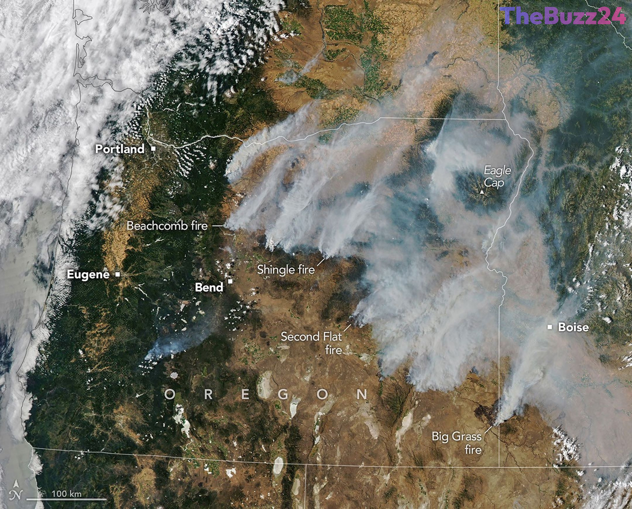
Fueled by extreme drought conditions, persistent summer heat, and erratic gusty winds, these initial sparks quickly evolved into massive, fast-moving fires. Satellite observations vividly illustrate the catastrophic scale of the disaster, capturing thick plumes of smoke streaming northeast from dozens of intense fire complexes. Major blazes—including the Hay Creek Complex, Brewer, Big Grass, Akawa Butte, and Powder River fires—have forced local authorities to issue widespread evacuation orders and stringent air quality advisories.
More than 10,000 personnel are currently deployed on the front lines, fighting tirelessly to contain the rapidly spreading infernos. State officials have invoked the Emergency Conflagration Act to mobilize additional resources and protect vulnerable communities from particularly aggressive threats like the Shingle, Bench, Beachcomb, and Second Flat fires. Meanwhile, the broader national picture remains grim, with total acreage burned across the United States outpacing the 10-year historical average for this point in the season.
Key Takeaways
- Lightning strikes from dry thunderstorms ignited numerous wildfires across central and eastern Oregon.
- More than one million acres have been burned in Oregon, contributing to a national total exceeding 4 million acres.
- Over 10,000 firefighters are actively battling the blazes while state officials enforce emergency protocols and air quality advisories.
Editor’s Analysis & Impact
The escalating severity of the 2026 wildfire season underscores a growing operational and economic challenge for emergency management infrastructure across the western United States. Prolonged drought conditions and higher regional temperatures are continuously altering fire behavior, turning standard seasonal burns into catastrophic, fast-moving events that routinely outpace traditional containment strategies. As satellite monitoring and real-time data systems become increasingly vital for tracking these disasters, federal and state agencies must adapt by scaling up preventative mitigation funding and expanding rapid-response capabilities. The broader economic implications include soaring firefighting expenditures, prolonged agricultural and tourism disruptions, and persistent public health crises driven by widespread particulate pollution.
Frequently Asked Questions
Q: What triggered the recent wildfires in Oregon?
A: The fires were primarily ignited by thousands of lightning strikes from dry thunderstorms that moved across the Cascade Range.
Q: How many acres have been burned in Oregon during this event?
A: As of late July 2026, the fires had scorched more than one million acres across the state.
Q: What tools do experts use to monitor these fires?
A: Scientists and emergency responders utilize advanced satellite instruments, such as NASA's MODIS, along with real-time tracking systems like FIRMS and the Worldview browser.
AI Disclosure: This article is based on verified data and official reports. Our Team and AI have cross-referenced every financial detail with primary sources to ensure total accuracy.
More from this Category