NISAR Satellite Captures Unprecedented Radar Imagery of Mount Rainier Through Dense Cloud Cover
The NASA-ISRO Synthetic Aperture Radar (NISAR) satellite has successfully demonstrated its advanced imaging capabilities by capturing a detailed view of Mount Rainier in Washington. By utilizing L-band Synthetic Aperture Radar (SAR) technology, the satellite effectively pierced through thick cloud cover that typically obscures the peak, providing a clear look at the terrain below. This mission marks a significant milestone in Earth observation, as the ability to maintain consistent monitoring regardless of weather conditions is essential for tracking environmental changes in the Pacific Northwest and beyond.
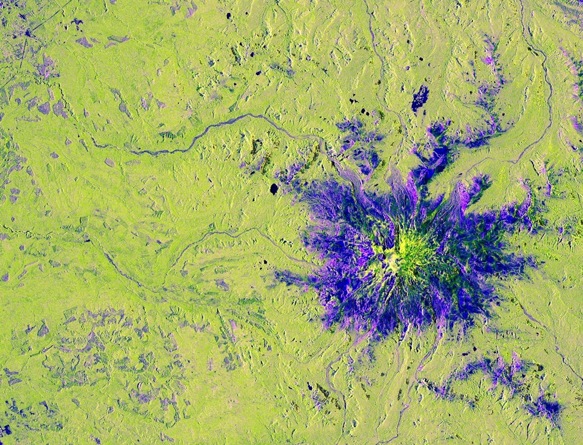
The imagery provided by the satellite utilizes a sophisticated color-coding system to differentiate between various surface types. Magenta highlights areas with strong radar reflections, often indicating man-made structures like roads or buildings. Vegetation, including the dense forests surrounding the mountain, appears in yellow-green, while smoother surfaces such as water bodies and clearings are rendered in dark blue. Notably, the data revealed purple square patterns at the base of the mountain, which researchers have identified as evidence of human activity, such as forest thinning or land management efforts.
Launched in July 2025 from India’s Satish Dhawan Space Centre, NISAR represents a major collaborative effort between NASA and the Indian Space Research Organisation (ISRO). The satellite is uniquely equipped with two distinct SAR instruments operating at different wavelengths, allowing for a level of versatility never before seen in space-based radar missions. The spacecraft features a massive 39-foot (12-meter) deployable antenna reflector, the largest ever deployed by NASA, which enables the satellite to conduct comprehensive observations of Earth’s land and ice surfaces every 12 days.
Key Takeaways
- The NISAR satellite uses L-band radar to capture high-resolution imagery of Earth's surface through dense cloud cover.
- The mission is a joint venture between NASA and ISRO, featuring the largest radar antenna reflector ever deployed by NASA.
- The satellite's data allows for precise identification of land use, vegetation health, and human-made structures, with a 12-day revisit cycle.
Editor’s Analysis & Impact
The successful deployment and operation of NISAR signal a paradigm shift in Earth observation technology. By combining L-band and S-band radar instruments, the mission provides a level of data granularity that was previously unattainable, particularly for regions plagued by persistent cloud cover. From a market and industry perspective, this technology has profound implications for climate science, disaster management, and urban planning. The ability to monitor glacier movement, deforestation, and infrastructure changes with such high frequency will likely become a cornerstone for environmental policy and resource management. As the mission continues, the data generated will likely catalyze new research in geophysics and ecology, setting a new standard for international space collaboration and providing a blueprint for future Earth-monitoring satellite constellations.
Frequently Asked Questions
Q: How does NISAR see through clouds?
A: NISAR uses Synthetic Aperture Radar (SAR), which emits radio waves that pass through clouds, smoke, and darkness, unlike optical cameras that rely on visible light.
Q: What is the significance of the 39-foot reflector?
A: The massive reflector is the largest radar antenna ever deployed by NASA, allowing the satellite to capture high-resolution data over a wide swath of the Earth's surface.
Q: How often does NISAR observe the same location?
A: The satellite is designed to conduct comprehensive observations of Earth's land and ice surfaces every 12 days.
AI Disclosure: This article is based on verified data and official reports. Our AI have cross-referenced every financial detail with primary sources to ensure total accuracy.
More from this Category