Satellite Technology Revolutionizes the Science of ‘Leaf Peeping’
The centuries-old tradition of tracking autumn foliage, known in Japan as momijigari and celebrated by poets and artists across the globe, has entered a new era of precision. While leaf peepers have historically relied on visual observation to track the seasonal shift of colors, advanced satellite technology is now providing a comprehensive, global view of how forests transform as temperatures drop and days shorten.
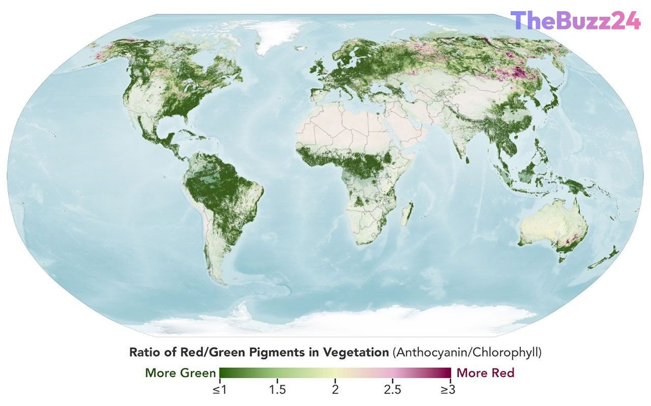
At the heart of this advancement is the Ocean Color Instrument (OCI) aboard the PACE satellite. Unlike previous sensors that offered limited, localized data, the OCI captures hyperspectral imagery across 286 spectral bands. This allows researchers to monitor the subtle chemical changes in leaves—specifically the degradation of chlorophyll and the emergence of anthocyanins and carotenoids—on a daily basis across the entire planet. By measuring the ratio of these pigments, scientists can map the progression of fall colors with unprecedented accuracy.
These satellite observations reveal the dynamic movement of color as it shifts from high-latitude regions like Alaska, Canada, and Russia toward the equator. While the data provides stunning visual maps of changing landscapes, it also serves a critical scientific purpose. By comparing satellite imagery with ground-level observations submitted by the public through the GLOBE program, researchers are gaining deeper insights into how environmental stressors, such as drought, insect infestations, and climate change, impact vegetation health and the global carbon cycle.
Beyond the aesthetic appeal of crimson and gold forests, this technology offers a window into the broader health of Earth’s ecosystems. As the PACE mission continues to collect time-series data, it is expected to play a vital role in monitoring wildfire risks and early warning signs of plant disease. For the public, the initiative provides a unique opportunity to contribute to scientific research by documenting local foliage, helping to bridge the gap between satellite-based remote sensing and the reality on the ground.
Key Takeaways
- The PACE satellite uses hyperspectral sensors to track the chemical pigments responsible for fall foliage on a global scale.
- Data from the OCI instrument allows scientists to monitor vegetation health, including responses to drought and insect damage.
- Public participation through the GLOBE program helps 'ground truth' satellite data, improving the accuracy of environmental research.
Editor’s Analysis & Impact
The integration of hyperspectral satellite data into phenology—the study of cyclic and seasonal natural phenomena—represents a significant leap in environmental monitoring. By moving beyond simple visual observation to chemical-level analysis, the PACE mission provides a scalable model for tracking ecosystem health in real-time. The implications for climate science are profound; understanding the timing of leaf senescence is essential for modeling the global carbon cycle and predicting how forests will respond to a warming climate. Furthermore, the crowdsourcing component of this research highlights a growing trend in ‘citizen science,’ where public engagement directly enhances the utility of high-cost government infrastructure. As these datasets grow, they will likely become indispensable for agricultural planning, wildfire management, and long-term ecological conservation efforts.
Frequently Asked Questions
Q: How does the satellite distinguish between fall colors and other vegetation changes?
A: The OCI instrument measures specific spectral bands associated with chlorophyll, carotenoids, and anthocyanins. While fall foliage shows a specific pattern of pigment change, scientists also cross-reference this data with ground-level observations to distinguish seasonal shifts from stress-induced changes caused by drought or disease.
Q: Can the public participate in this research?
A: Yes, the public can contribute to the North American Phenology Campaign via the GLOBE program by submitting photos of local vegetation. These ground-level observations help scientists verify and refine the data collected by the PACE satellite.
AI Disclosure: This article is based on verified data and official reports. Our Team and AI have cross-referenced every financial detail with primary sources to ensure total accuracy.
More from this Category