Northern Thailand Faces Severe Air Quality Crisis as Seasonal Haze Intensifies
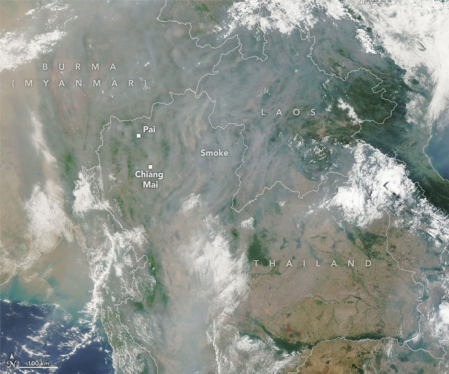
Northern Thailand is currently enduring a severe seasonal air quality crisis, with the city of Chiang Mai and surrounding provinces blanketed in a thick, hazardous haze. As the region moves through the dry months of March and April, the picturesque mountainous terrain has been obscured by smoke, leading to significantly reduced visibility and a sharp decline in public health conditions. Satellite imagery from late April 2026 highlights the extent of the pollution, showing valleys and ridges trapped under a persistent layer of airborne particulates.
The crisis is primarily fueled by widespread agricultural and forest fires, which are frequently used to clear crop residue or manage land. These fires account for approximately 70 percent of the fine particulate matter (PM2.5) in the region during the peak of the season. While biomass burning is the leading cause, the situation is exacerbated by vehicle emissions, industrial activity, and the region’s unique topography. The narrow valleys, surrounded by mountains, often experience temperature inversions that trap pollutants, preventing them from dispersing and creating a stagnant, toxic environment.
The impact of this pollution is both medical and economic. Ground-based sensors have consistently recorded ‘unhealthy’ and ‘very unhealthy’ air quality levels, raising alarms about long-term respiratory and cardiovascular risks for residents. Simultaneously, the tourism industry is suffering, with some popular destinations reporting a 90 percent drop in visitor arrivals. Meteorological forecasts indicate that the combination of unusually warm, dry weather and prevailing wind patterns will likely sustain these hazardous conditions for the near future, posing a continued challenge for the Mekong sub-region.
Key Takeaways
- Agricultural and forest fires are responsible for roughly 70% of the PM2.5 pollution in Northern Thailand during the dry season.
- The region's mountainous geography traps pollutants, preventing natural air circulation and worsening the impact of the haze.
- The ongoing air quality crisis has caused a significant decline in local tourism, with some areas seeing a 90% drop in visitors.
Editor’s Analysis & Impact
The recurring air quality crisis in Northern Thailand represents a complex intersection of traditional agricultural practices, regional climate patterns, and economic vulnerability. The reliance on biomass burning for land management remains a difficult policy hurdle, as it is deeply ingrained in local farming economies. From a market perspective, the persistent haze is a major deterrent for the tourism sector, which is a vital pillar of the regional economy. Future outlooks remain grim unless there is a coordinated transboundary effort to manage agricultural fires and implement sustainable land-use policies. The reliance on meteorological conditions to clear the air is no longer a viable long-term strategy, and the region faces increasing pressure to modernize its agricultural waste management to prevent further health and economic degradation.
Frequently Asked Questions
Q: Why is the air quality in Northern Thailand worse during March and April?
A: The air quality worsens during these months due to a combination of dry weather conditions and the peak season for agricultural and forest fires, which are used to clear land and crop residue.
Q: What is the main health risk associated with the current haze?
A: The primary health risk is the high concentration of PM2.5 particulate matter, which can lead to severe respiratory and cardiovascular ailments due to prolonged exposure.
AI Disclosure: This article is based on verified data and official reports. Our AI have cross-referenced every financial detail with primary sources to ensure total accuracy.
More from this Category