Satellite Imagery Reveals Rapid Subsidence Crisis in Mexico City
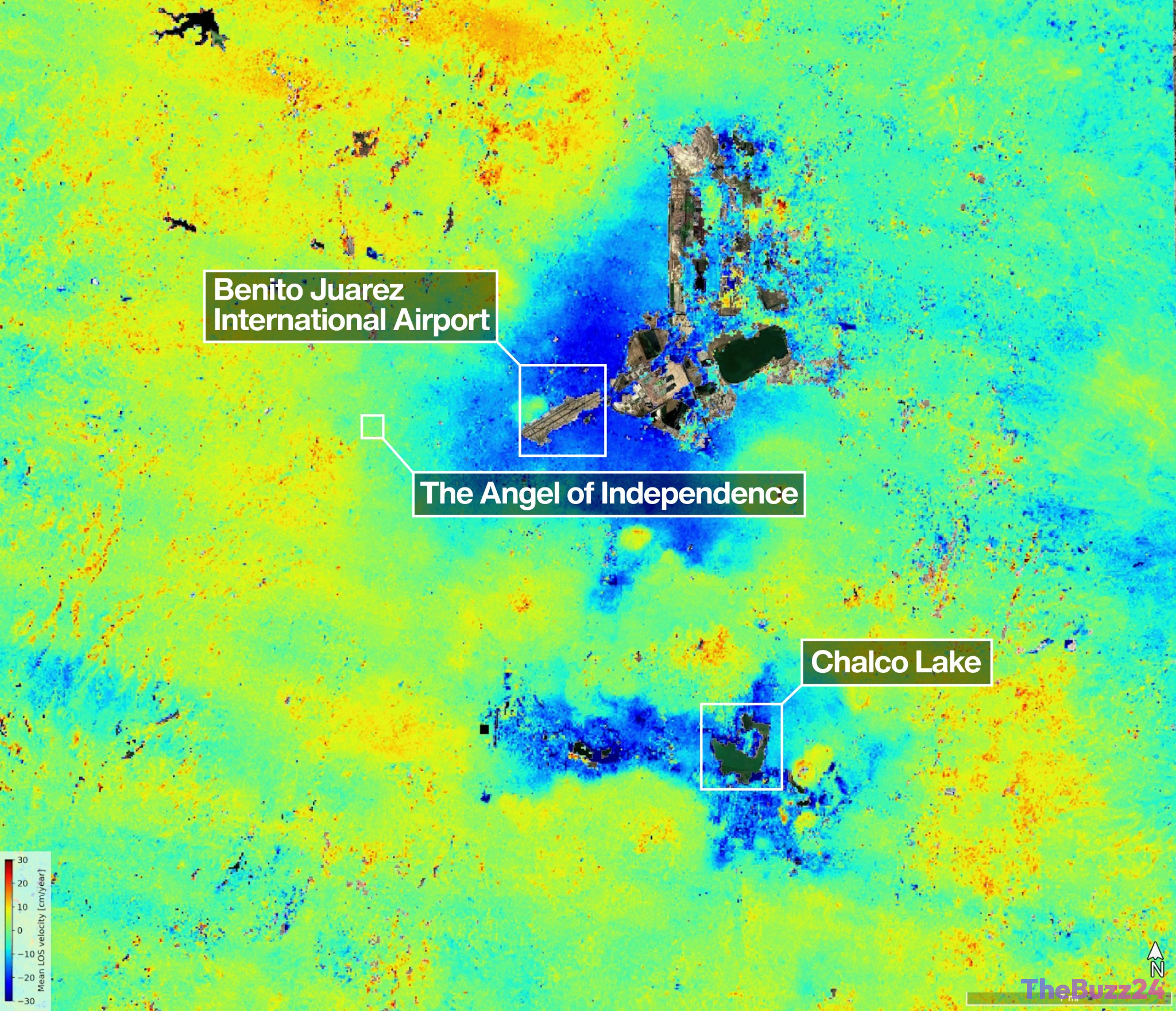
Advanced radar data from the recently deployed NISAR satellite mission has unveiled a concerning acceleration in geological instability across Mexico City. Observations conducted between October 2025 and January 2026 indicate that specific metropolitan zones are sinking at a rate surpassing two centimeters per month. By utilizing high-frequency L-band synthetic aperture radar, researchers can now track minute ground deformations with extreme precision, unaffected by cloud cover or dense urban vegetation.
This sinking phenomenon is deeply rooted in the city’s historical geography. Built upon the soft, compressible soil of an ancient lakebed, the metropolitan area has struggled with structural settling for over a century. This natural instability is significantly worsened by the immense weight of modern urban infrastructure and the ongoing, large-scale extraction of groundwater. The resulting compaction has already caused visible damage to critical systems, including the city’s Metro network, and has forced engineers to make structural adjustments to iconic landmarks like the Angel of Independence monument, which now requires additional steps at its base to compensate for the shifting terrain.
The NISAR mission, which features the largest radar antenna reflector ever launched by NASA, provides a comprehensive global scan every 12 days. While the mission is currently providing vital insights into Mexico City’s subsidence, its capabilities extend to monitoring glacier dynamics and agricultural shifts worldwide. Urban planners and civil engineers are expected to leverage this high-resolution data to develop more robust mitigation strategies, aiming to protect essential infrastructure in cities facing similar geological challenges.
Key Takeaways
- New satellite data confirms that parts of Mexico City are sinking by more than two centimeters monthly.
- The subsidence is primarily caused by the city's construction on an ancient lakebed, compounded by groundwater extraction and heavy infrastructure.
- The NISAR mission provides high-resolution, global radar monitoring every 12 days to assist in urban planning and disaster mitigation.
Editor’s Analysis & Impact
The data provided by the NISAR mission underscores a growing tension between rapid urbanization and geological limitations. Mexico City acts as a critical case study for the risks inherent in building on reclaimed, unstable land. As global populations concentrate in metropolitan centers, the ability to monitor ground deformation with such high precision is no longer a luxury but a necessity for civil engineering and disaster prevention. The economic impact is profound; cities worldwide will likely face increased pressure to invest in infrastructure resilience and sustainable water management to avoid the failure of vital transport and utility networks. Moving forward, this satellite data will likely force a paradigm shift in urban zoning and construction, pushing architects and planners toward more adaptive, ground-sensitive standards to ensure the long-term viability of sinking urban environments.
Frequently Asked Questions
Q: Why is Mexico City sinking?
A: Mexico City is sinking because it is built on an ancient lakebed. The combination of the heavy weight of urban infrastructure and the continuous extraction of groundwater causes the underlying soil to compact over time.
Q: What is the NISAR mission?
A: NISAR is a satellite mission that utilizes advanced radar technology to monitor subtle changes in the Earth's surface, including land subsidence, glacier movement, and agricultural development, with global coverage every 12 days.
AI Disclosure: This article is based on verified data and official reports. Our Team and AI have cross-referenced every financial detail with primary sources to ensure total accuracy.
More from this Category