Mega-Tsunami in Alaska: How a Massive Landslide Reshaped Tracy Arm Fjord
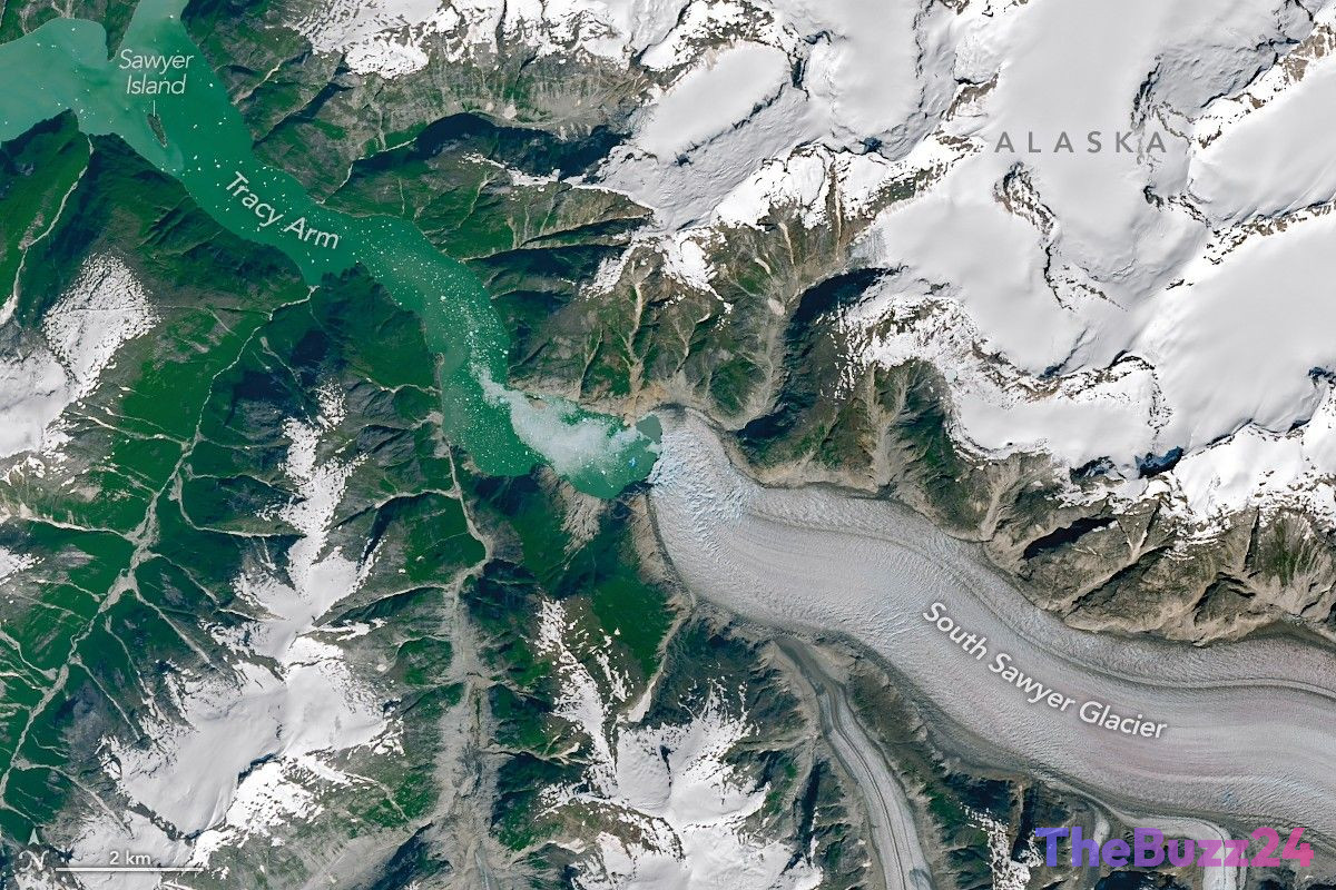
In August 2025, a colossal geological event dramatically reshaped the landscape of Tracy Arm, a prominent fjord in southeast Alaska. Following the rapid retreat of the South Sawyer Glacier, a massive landslide sent approximately 64 million cubic meters of rock plunging into the fjord. This sudden displacement of material triggered a catastrophic localized tsunami, which reached an astonishing peak runup height of 1,578 feet (481 meters). The sheer force of the wave stripped mature forests and vegetation from the steep fjord walls, leaving behind barren, brown scars visible from space.
Satellite observations captured before and after the August 10 disaster highlight the scale of the destruction. Entire islands, including Sawyer Island located six miles away from the slide, were transformed from lush green to desolate brown, with only a few high-elevation trees surviving. A comprehensive study published in the journal Science detailed how the landslide and the subsequent water sloshing—known as a seiche—generated seismic waves equivalent to a magnitude 5.4 earthquake, which were detected by monitoring stations worldwide.
The event also had an immediate impact on the South Sawyer Glacier itself. The landslide sheared off a massive portion of the glacier’s terminus, filling the fjord with a dense slurry of icebergs. While no human casualties were reported, the event caught several outdoor enthusiasts by surprise, including kayakers who lost their gear to sudden surges. Geologists point out that the rapid retreat of glaciers, which destabilizes surrounding slopes and exposes deep water, serves as a critical warning sign for future landslide and tsunami hazards in warming regions.
Key Takeaways
- A massive landslide of 64 million cubic meters of rock triggered a mega-tsunami in Alaska's Tracy Arm fjord, reaching a peak runup height of 1,578 feet.
- The geological event was so powerful that it generated global seismic signals equivalent to a magnitude 5.4 earthquake and caused the fjord's waters to slosh for over a day.
- Rapid glacial retreat is identified as a primary driver of slope instability, highlighting a growing hazard for maritime tourism and local ecosystems in high-latitude regions.
Editor’s Analysis & Impact
The Tracy Arm incident underscores a growing and volatile intersection between climate change, geological hazards, and the global tourism industry. As glaciers rapidly retreat due to rising global temperatures, they leave behind unstable rock faces and newly exposed deep-water fjords—creating the perfect conditions for catastrophic landslides and localized mega-tsunamis. For the cruise and maritime travel industries, which heavily frequent scenic Alaskan fjords, this event serves as a stark wake-up call. Several cruise operators have already begun altering their itineraries to avoid high-risk zones. Moving forward, the integration of real-time satellite monitoring and seismic warning systems will be crucial. Governments and private operators must invest in predictive geology to safeguard tourists and coastal infrastructure, as these high-magnitude natural events are projected to increase in frequency as polar ice continues to melt.
Frequently Asked Questions
Q: What caused the massive landslide and tsunami in Tracy Arm?
A: The event was primarily driven by the rapid retreat of the South Sawyer Glacier, which destabilized the surrounding valley walls. This instability, potentially compounded by moderate rainfall, caused 64 million cubic meters of rock to collapse into the fjord, triggering the mega-tsunami.
Q: How high did the tsunami wave reach?
A: The tsunami reached a peak runup height of 1,578 feet (481 meters) along the opposing fjord wall, stripping away trees and vegetation and leaving a distinct 'bathtub ring' of destruction.
Q: Were there any casualties or major impacts on tourism?
A: Fortunately, no injuries or deaths were reported, though some kayakers lost their gear. However, the event has prompted cruise companies to reassess safety protocols, with some avoiding popular excursions into Tracy Arm due to ongoing geological risks.
AI Disclosure: This article is based on verified data and official reports. Our Team and AI have cross-referenced every financial detail with primary sources to ensure total accuracy.
More from this Category