Super Typhoon Bavi Batters Pacific Islands in Historic Category 5 Strike
In early July 2026, the U.S. Northern Mariana Islands and Guam faced a devastating blow as Super Typhoon Bavi swept through the region. Marking the second major storm to strike the area in just three months, the typhoon reached peak intensity on the night of July 5, packing sustained winds of 290 kilometers (180 miles) per hour. The storm brought torrential rainfall and a dangerous storm surge, causing significant infrastructure damage, including downed power lines, flooded roadways, and the destruction of critical facilities like water distribution stations on Rota.
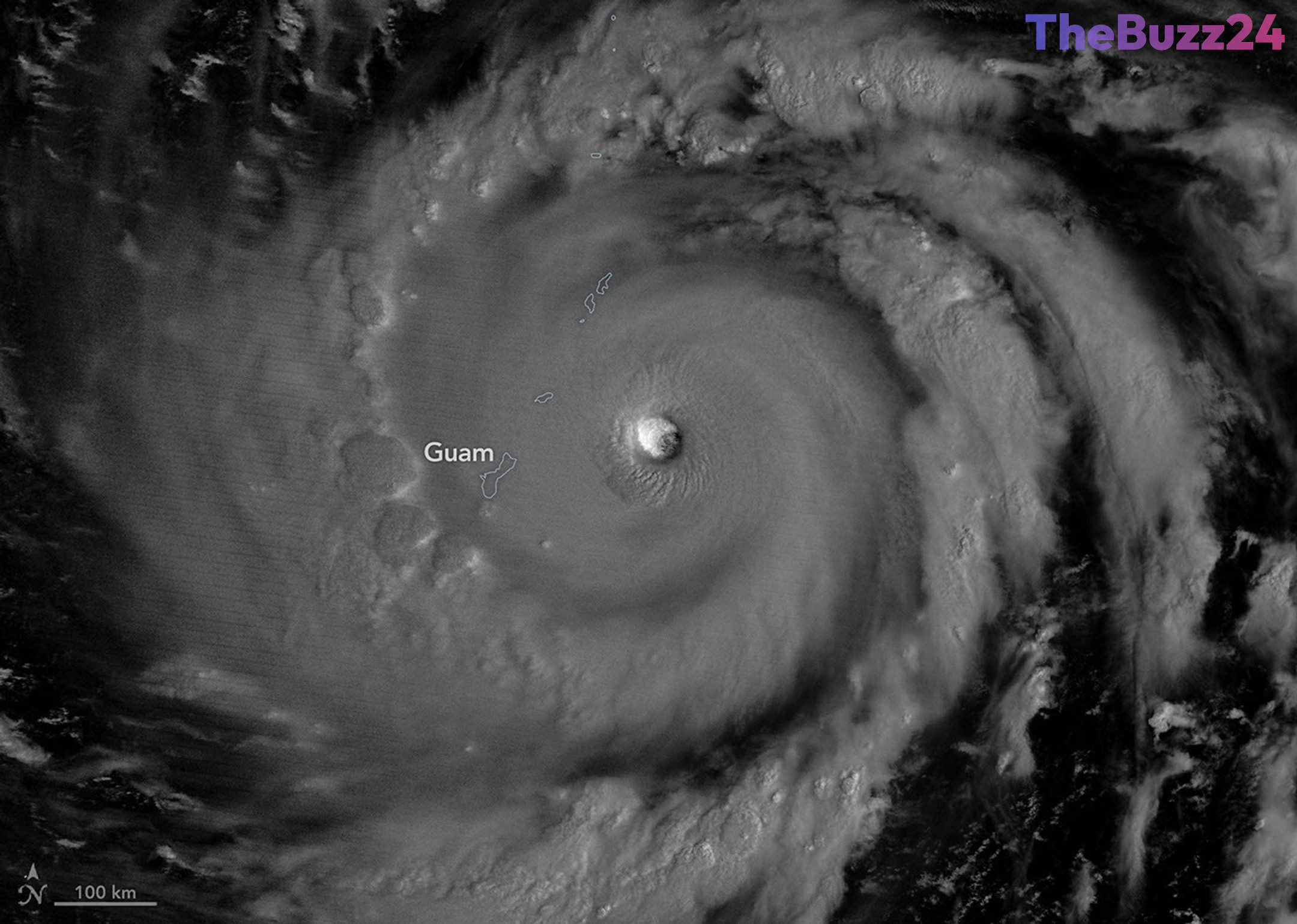
Satellite imagery captured by the VIIRS instrument on the NOAA-20 satellite provided a haunting view of the storm’s eyewall, illuminated by moonlight as it passed over the islands. Bavi, which reached Category 5 status on the Saffir-Simpson scale, benefited from exceptionally warm sea surface temperatures of approximately 30 degrees Celsius (86 degrees Fahrenheit). This environment allowed the storm to rapidly intensify as it tracked westward across the North Pacific.
Recovery efforts are currently underway, with Coast Guard crews working to clear navigation hazards and reopen ports essential for the islands’ supply chains. This latest disaster follows the destruction caused by Super Typhoon Sinlaku, which impacted the same region in mid-April. As Bavi continues its path toward the Philippine Sea, meteorologists are monitoring its trajectory toward Taiwan, the Ryukyu Islands, and mainland China, noting that the storm’s intensity is consistent with patterns observed during developing El Niño events, which often provide tropical cyclones more time to strengthen over warm waters.
Key Takeaways
- Super Typhoon Bavi struck Guam and the Northern Mariana Islands as a Category 5 storm, causing widespread infrastructure damage.
- The storm is the third Category 5 cyclone of 2026, fueled by unusually warm ocean temperatures.
- Meteorologists link the storm's intensity to building El Niño conditions, which allow typhoons to gain more power before reaching land.
Editor’s Analysis & Impact
The recurrence of back-to-back Category 5 typhoons in the Northern Mariana Islands highlights the increasing vulnerability of Pacific territories to extreme weather events. From an economic perspective, the repeated destruction of critical infrastructure—such as water stations and port facilities—places a significant strain on local government budgets and regional supply chains. The correlation between these intense storms and developing El Niño patterns suggests that climate-driven atmospheric changes are shifting the traditional behavior of tropical cyclones. Moving forward, regional authorities will likely need to prioritize more resilient infrastructure designs and enhanced disaster preparedness protocols to mitigate the long-term financial and social costs of these increasingly frequent, high-intensity weather events.
Frequently Asked Questions
Q: What made Super Typhoon Bavi so intense?
A: Bavi reached Category 5 intensity due to exceptionally warm sea surface temperatures of around 30 degrees Celsius, which provided the necessary energy for rapid intensification.
Q: How does an El Niño event affect typhoon formation?
A: During El Niño years, typhoons often form further east in the Pacific, giving them a longer path over warm ocean waters to intensify before they eventually curve toward Asia.
AI Disclosure: This article is based on verified data and official reports. Our Team and AI have cross-referenced every financial detail with primary sources to ensure total accuracy.
More from this Category