Tracking the Invisible Threat: How NASA’s MAIA Sensors Are Mapping Air Pollution in Addis Ababa
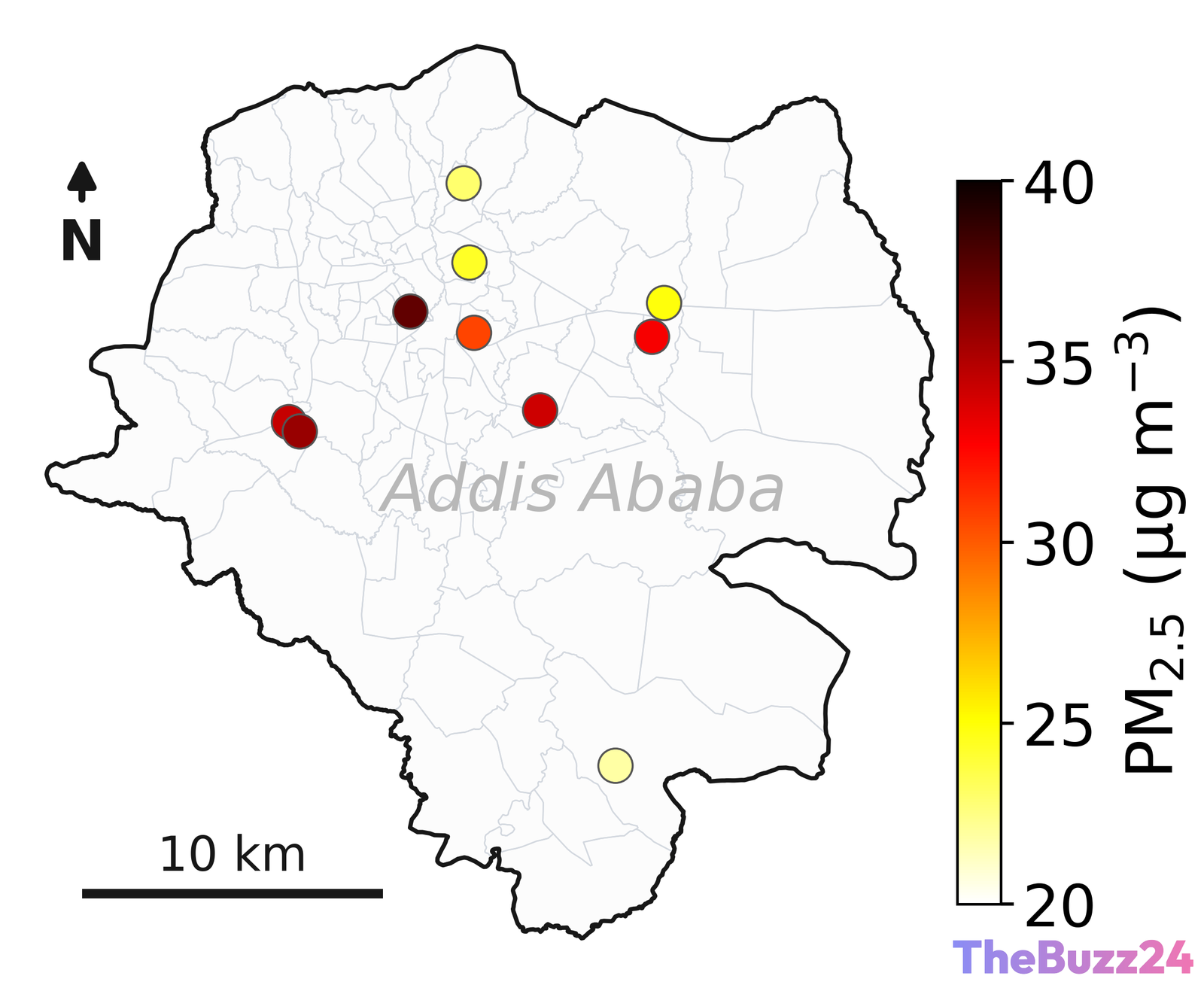
A network of ten advanced air sensors deployed across Addis Ababa, Ethiopia, is providing unprecedented insights into the city’s air quality. This localized monitoring effort is part of the Multi-Angle Imager for Aerosols (MAIA) mission, which has spent three years measuring fine particulate matter (PM2.5) and black carbon (soot) in the capital. The initiative highlights a critical global push to understand urban air pollution and its severe, direct consequences on public health.
Black carbon, a major component of the pollution in Addis Ababa, is primarily produced by diesel vehicles, open fires, and other combustion sources. Exposure to these fine particles has been scientifically linked to severe health issues, including low birth weight, impaired childhood brain development, chronic respiratory conditions, and premature mortality. Data collected by the MAIA sensors reveals distinct pollution patterns, showing significant spikes during peak traffic hours and major holiday celebrations, offering a blueprint for understanding urban emissions worldwide.
The MAIA mission is not limited to East Africa; it targets 12 key regions globally, including major U.S. metropolitan areas such as Los Angeles, Atlanta, and Boston. The project combines this active ground-based sensor network with a future space observatory. A specialized camera, developed by the Jet Propulsion Laboratory, is scheduled to launch on an Italian Space Agency (ASI) satellite in late 2027. This camera will analyze how light reflects off particles, allowing scientists to identify and map specific aerosol concentrations from orbit.
Key Takeaways
- NASA's MAIA mission has deployed 10 ground sensors in Addis Ababa to monitor PM2.5 and black carbon levels over a three-year period.
- The collected data shows that air pollution spikes during rush-hour traffic and holiday events, with diesel emissions and fires being primary contributors.
- The ground-based network will eventually integrate with a space observatory scheduled for launch in late 2027 to map global aerosol concentrations.
Editor’s Analysis & Impact
The MAIA mission represents a pivotal shift in how global environmental health is monitored, bridging the gap between localized ground data and macro-level satellite observations. By focusing on PM2.5 and black carbon, the project addresses some of the most hazardous pollutants affecting urban populations today. The integration of space-based imaging with ground sensors will provide policymakers and urban planners with highly actionable, real-time data to combat air pollution. Furthermore, this collaborative effort between international space agencies highlights the growing trend of utilizing space technology for direct public health benefits. As urbanization accelerates, particularly in developing nations, such high-resolution monitoring systems will become essential tools for designing cleaner, healthier cities.
Frequently Asked Questions
Q: What is the primary goal of the MAIA mission in Addis Ababa?
A: The mission aims to map and analyze fine particulate matter (PM2.5) and black carbon (soot) to understand how air pollution levels fluctuate over time and to study their impact on human health.
Q: How do the MAIA sensors distinguish between different types of air pollution?
A: The upcoming space observatory will use a specialized camera designed to analyze how different aerosol particles reflect light, allowing scientists to identify and map specific types of particulate matter.
Q: When will the space-based component of the MAIA mission launch?
A: The space observatory, featuring a camera built by the Jet Propulsion Laboratory, is scheduled to launch on an Italian Space Agency satellite no earlier than late 2027.
AI Disclosure: This article is based on verified data and official reports. Our Team and AI have cross-referenced every financial detail with primary sources to ensure total accuracy.
More from this Category