El Niño Returns: Satellite Data Confirms Strengthening Pacific Warming
The equatorial Pacific Ocean has officially entered an El Niño phase, a recurring climate phenomenon characterized by significantly warmer-than-average sea surface temperatures. Following months of monitoring, official declarations were made in June 2026 after temperatures in the central and eastern Pacific consistently measured at least 0.5 degrees Celsius above the long-term average. This shift in ocean conditions is expected to have far-reaching impacts on global weather patterns, potentially increasing rainfall in the U.S. Southwest while heightening the risk of drought in regions like Indonesia and Australia.
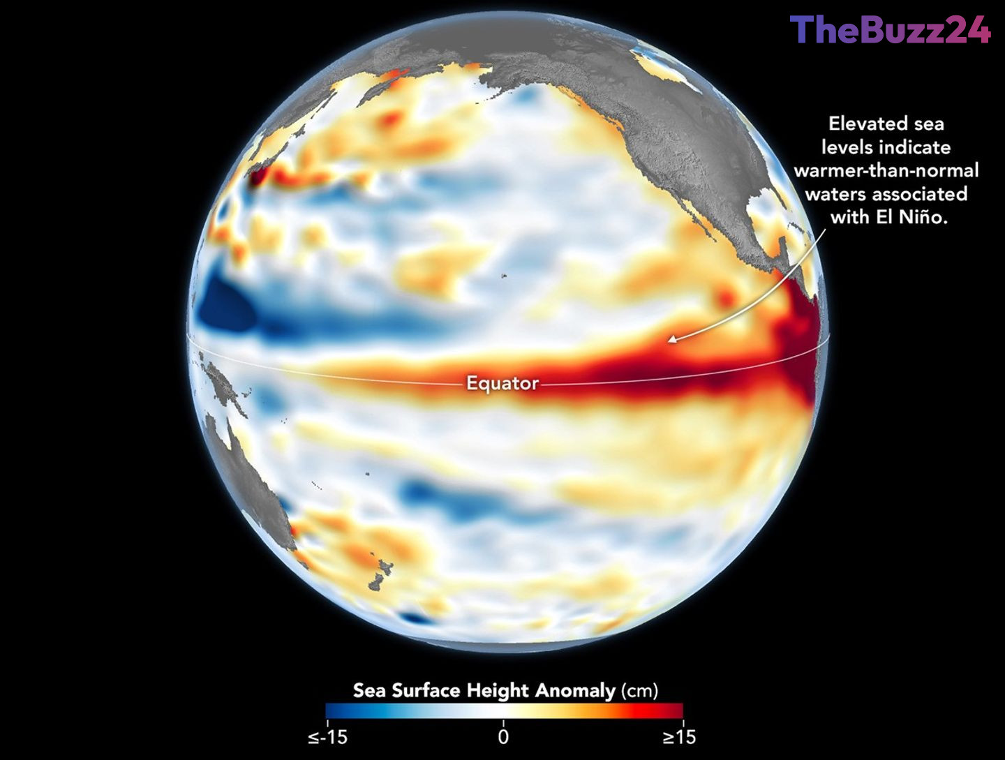
Advanced satellite technology, specifically the Sentinel-6 Michael Freilich mission, has been instrumental in tracking the development of this event. By measuring sea surface height, researchers can effectively map the distribution of heat across the ocean. Because warmer water expands, higher sea levels serve as a reliable proxy for subsurface heat content. Earlier this spring, the satellite detected Kelvin waves—large swells of warm water moving from the western to the eastern Pacific—which acted as a precursor to the current warming trend.
Scientists at the Jet Propulsion Laboratory are closely analyzing these data points to determine the potential intensity of the 2026 event. While current conditions show similarities to the powerful El Niño of 1997, researchers note that the eastern Pacific warming has lagged slightly behind that historic benchmark. As additional warm Kelvin waves continue to move across the ocean, experts are maintaining a vigilant watch to see if the current El Niño will reach extreme levels or stabilize in the coming weeks.
Key Takeaways
- An El Niño event was officially declared in June 2026 following sustained temperature anomalies in the equatorial Pacific.
- Satellite data from the Sentinel-6 Michael Freilich mission is being used to track sea surface height as a primary indicator of heat storage.
- The phenomenon is expected to cause significant climate shifts, including increased precipitation in the U.S. Southwest and potential droughts in the western Pacific.
Editor’s Analysis & Impact
The return of El Niño presents significant implications for global agricultural, energy, and disaster management sectors. Historically, El Niño events disrupt global weather patterns, leading to volatile commodity prices due to crop failures in drought-stricken regions or infrastructure damage from extreme precipitation. From an industry perspective, the ability to track these events with high-precision satellite data allows for better predictive modeling, which is crucial for insurance markets and supply chain logistics. However, the uncertainty regarding the intensity of the 2026 event highlights the ongoing challenge of climate volatility. As the world becomes more interconnected, the economic ripple effects of such climate phenomena are likely to intensify, necessitating more robust adaptation strategies for both governments and private enterprises to mitigate the risks associated with shifting ocean temperatures.
Frequently Asked Questions
Q: What is the primary indicator used to track El Niño?
A: The primary indicators are warmer-than-average sea surface temperatures and elevated sea surface heights in the central and eastern equatorial Pacific.
Q: How does El Niño affect global weather?
A: El Niño typically causes wetter conditions in the U.S. Southwest and increases the likelihood of drought in western Pacific nations like Indonesia and Australia.
AI Disclosure: This article is based on verified data and official reports. Our Team and AI have cross-referenced every financial detail with primary sources to ensure total accuracy.
More from this Category