Rare Pileus Cloud Captured Hovering Over Montana Wildfire’s Pyrocumulus Plume
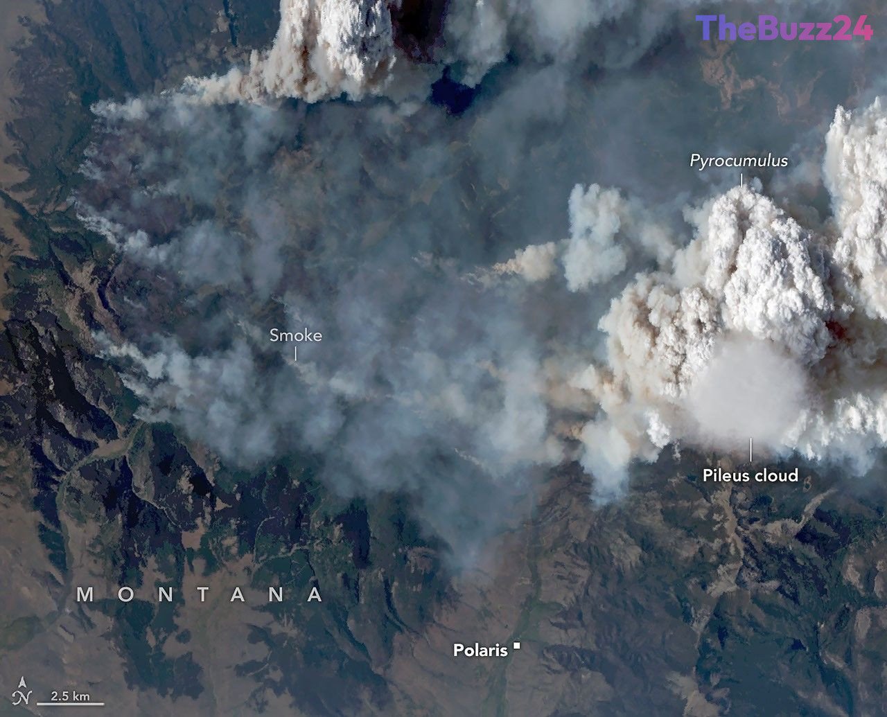
Atmospheric researchers flying over the Sand Creek fire in Montana have managed to capture a rare and striking meteorological phenomenon: a smooth, veil-like pileus cloud resting directly atop a towering pyrocumulus cloud. Documented during an aerial mission, this ephemeral cap cloud offered scientists an unprecedented look into the intense convective forces generated by aggressive wildfires.
The mission forms part of an ongoing airborne research campaign designed to investigate smoke-infused fire clouds and their atmospheric impacts. While pileus clouds—derived from the Latin word for “cap”—are typically observed forming above severe thunderstorms or volcanic eruptions when rapid updrafts force moist air upward, seeing one interact with a wildfire plume in such precise detail is exceptionally uncommon. In this instance, the fast-rising smoke and heat plume acted similarly to a physical mountain, lifting ambient moisture high into the atmosphere where it rapidly condensed.
Advanced high-altitude sensor equipment recorded the event using multiple spectral bands, capturing both the visible structure of the cap cloud and shortwave-infrared data mapping the fire’s intense surface perimeter. Researchers noted that the fleeting nature of the pileus—persisting for only a few minutes before dissolving into the greater convective column—highlights the extreme updraft dynamics at play as the wildfire surged up local mountain terrain.
By successfully linking surface-level fire behavior with upper-atmosphere cloud processes, the data collected during the flight provides vital insights into how extreme wildfire plumes evolve. Understanding these mechanics helps meteorologists and emergency management teams better predict the behavior of massive fire-induced weather systems and their broader environmental consequences.
Key Takeaways
- Researchers flying over Montana's Sand Creek fire captured a rare pileus cloud resting on top of a pyrocumulus fire cloud.
- The fleeting cap cloud formed when intense heat and fast-rising updrafts from the wildfire forced upper-layer moisture to rapidly condense.
- Advanced airborne sensors successfully mapped both surface fire behavior and upper-atmosphere cloud dynamics during the research flight.
Editor’s Analysis & Impact
The intersection of extreme wildfire behavior and atmospheric science represents a rapidly expanding frontier in meteorological research. As severe wildfire seasons become more frequent and intense globally, understanding the mechanics of pyrocumulonimbus and pyrocumulus clouds is critical for predicting localized weather anomalies, smoke dispersion, and fire propagation. Campaigns utilizing high-altitude research aircraft and multi-spectral imaging provide unprecedented visibility into how immense thermal energy alters local atmospheric chemistry and dynamics. These insights not only enhance our understanding of Earth systems science but also directly inform future predictive models used by emergency management and firefighting agencies facing increasingly complex environmental hazards.
Frequently Asked Questions
Q: What is a pileus cloud?
A: A pileus cloud is a smooth, veil-like cap cloud that typically forms when a rapidly rising column of air—such as from a thunderstorm, volcanic eruption, or intense wildfire—forces a moist layer of air aloft to rise and condense quickly.
Q: Why are pileus clouds rarely seen with wildfires?
A: While pileus clouds are well-documented over severe weather systems, capturing one interacting with a wildfire plume (pyrocumulus) requires precise timing, as these cap clouds are usually extremely short-lived, often lasting only a few minutes.
Q: How do researchers study fire-induced clouds?
A: Scientists utilize high-flying research aircraft equipped with advanced sensors, such as multi-spectral imagers and downward-pointing radars, to simultaneously monitor surface fire dynamics and upper-level cloud structures.
AI Disclosure: This article is based on verified data and official reports. Our Team and AI have cross-referenced every financial detail with primary sources to ensure total accuracy.
More from this Category