Satellite Imagery Captures Typhoon Jangmi’s Path Toward Japan
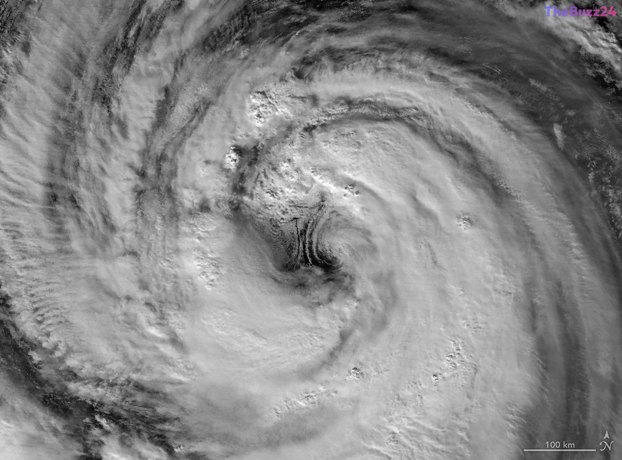
In late May and early June 2026, a powerful, slow-moving storm system identified as Typhoon Jangmi tracked north-northwest across the Philippine Sea, posing a significant weather threat to southern Japan. The storm, characterized by expansive rainbands, brought the risk of severe flooding to coastal regions as it moved steadily toward the Japanese archipelago.
Advanced satellite technology, specifically the Visible Infrared Imaging Radiometer Suite (VIIRS) aboard the Suomi NPP and NOAA-20 satellites, provided detailed nighttime observations of the storm’s structure. On May 30, the typhoon exhibited sustained winds of approximately 120 kilometers per hour, placing it in the category 1 classification on the Saffir-Simpson scale. Meteorologists noted that the storm possessed a notably large eye, with evidence of mesocyclones—low-level rotational features—present on the eastern periphery.
By May 31, the storm had intensified slightly, with sustained winds reaching 130 kilometers per hour. While the eye of the typhoon remained south of Okinawa during this period, the outer cloud bands began impacting landmasses. Forecasts indicated that the system would track toward the Amami region, with authorities warning of heavy rainfall and potential hazards along the Pacific coast of Japan throughout the early days of June.
Key Takeaways
- Typhoon Jangmi tracked toward southern Japan in late May 2026, bringing heavy rainfall and flooding risks.
- Satellite data confirmed the storm reached category 1 intensity, with sustained winds peaking at 130 km/h.
- Meteorological observations highlighted a large eye structure and the presence of mesocyclones within the storm's cloud bands.
Editor’s Analysis & Impact
The tracking of Typhoon Jangmi highlights the critical role of satellite remote sensing in modern disaster management and meteorological forecasting. By utilizing high-resolution infrared imaging, scientists can monitor the internal dynamics of tropical cyclones—such as eyewall development and mesocyclone activity—in real-time, even during nighttime hours. This capability is essential for improving the accuracy of landfall predictions and intensity forecasting, which directly impacts public safety and infrastructure protection in vulnerable coastal regions. As climate patterns continue to shift, the ability to observe these storms with such precision becomes increasingly vital for global disaster preparedness. The data gathered from such events contributes to a broader understanding of atmospheric behavior, ultimately refining the models used to predict the trajectory and impact of extreme weather events in the Pacific basin.
Frequently Asked Questions
Q: What was the intensity of Typhoon Jangmi when it was near Okinawa?
A: At its peak observation period, Typhoon Jangmi reached sustained winds of 130 kilometers per hour, equivalent to a category 1 storm on the Saffir-Simpson scale.
Q: How did scientists observe the storm at night?
A: Scientists utilized the Visible Infrared Imaging Radiometer Suite (VIIRS) day-night band data from satellites to capture detailed imagery of the storm's structure in the absence of sunlight.
AI Disclosure: This article is based on verified data and official reports. Our Team and AI have cross-referenced every financial detail with primary sources to ensure total accuracy.
More from this Category