Prehistoric Lake Agassiz: The Ancient Legacy Shaping Canada’s Agricultural Powerhouse
Approximately 15,000 years ago, a colossal glacial body of water, known as Lake Agassiz, dominated the central North American landscape. Formed by the retreating Laurentide Ice Sheet, this prehistoric giant spanned vast areas now encompassing parts of Manitoba, Ontario, Saskatchewan, Minnesota, and North Dakota. Holding more water than all of the present-day Great Lakes combined, its eventual collapse roughly 12,000 years ago, when its ice dam gave way, dramatically reshaped the continent. The immense volume of water drained, leaving behind an expansive, remarkably flat basin characterized by deep, exceptionally fertile silt and clay deposits.
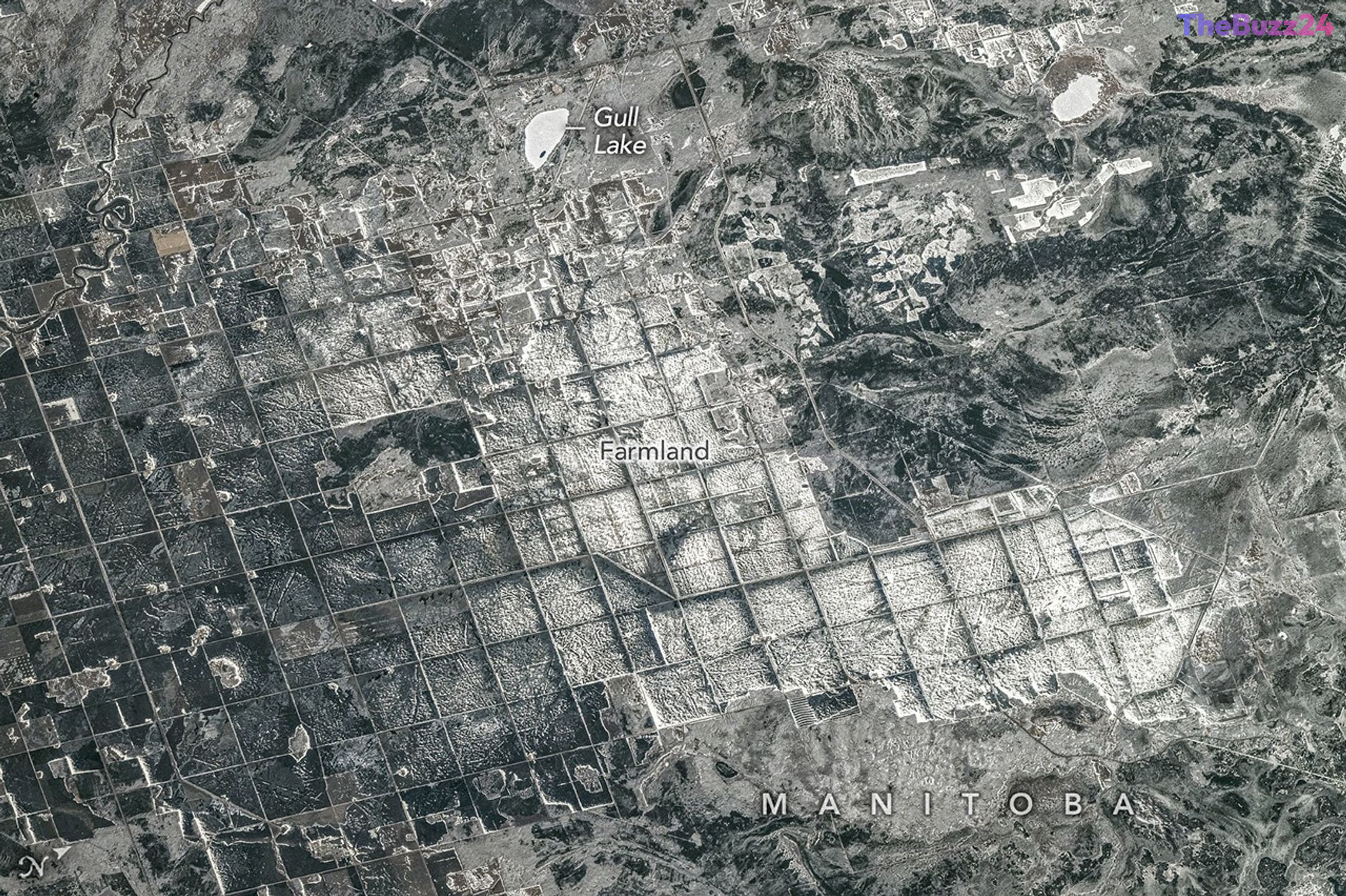
This monumental geological event inadvertently laid the groundwork for one of North America’s most productive agricultural regions. The landscape’s distinctive organization is further defined by the 19th-century Dominion Land Survey, which meticulously divided the territory into a precise grid of one-square-mile sections. This rigid, geometric structure remains so prominent that it is easily discernible from space, with satellite imagery revealing a striking tapestry of roads, irrigation canals, and vast fields that characterize the modern agricultural heartland.
Today, this ancient lakebed forms a critical pillar of the Canadian economy, facilitating the large-scale cultivation of essential crops such as canola, wheat, barley, and oats. Recent observations, including imagery captured from the International Space Station, continue to underscore the profound and enduring influence of this prehistoric basin, particularly evident near the southern shores of Lake Winnipeg. Beyond its significant agricultural output, the region also sustains vital ecosystems and serves as a hub for recreational activities, showcasing a unique convergence where deep geological history continues to shape contemporary economic prosperity and community development.
Key Takeaways
- Lake Agassiz, a massive prehistoric glacial lake, created North America's fertile agricultural heartland by depositing nutrient-rich soil upon its drainage 12,000 years ago.
- The region's distinctive, grid-like farm layout is a direct result of the 19th-century Dominion Land Survey, a structure still clearly visible from space.
- This former lakebed is crucial for Canada's economy and global food supply, producing significant quantities of staple crops like canola, wheat, barley, and oats.
Editor’s Analysis & Impact
The geological legacy of Lake Agassiz offers a compelling illustration of how ancient environmental processes fundamentally shape modern economic landscapes. By providing an exceptionally flat and nutrient-rich foundation, this prehistoric basin enabled the development of a highly efficient, large-scale agricultural belt critical for global food security. However, this reliance on a specific geological formation presents future challenges. As climate patterns evolve, the region’s clay-heavy soil and flat topography will necessitate increasingly sophisticated water management and soil conservation strategies to sustain productivity. Furthermore, the tension between the rigid, historical grid system of the Dominion Land Survey and contemporary ecological preservation efforts, such as wetland restoration, will be a defining factor in the region’s long-term sustainability. The area stands as a testament to the ongoing need to balance human ingenuity with the inherent constraints and opportunities presented by natural history.
Frequently Asked Questions
Q: What was Lake Agassiz?
A: Lake Agassiz was an enormous prehistoric glacial lake that existed approximately 15,000 years ago, formed by the melting Laurentide Ice Sheet across central North America.
Q: How did Lake Agassiz contribute to the region's agricultural success?
A: When the lake drained about 12,000 years ago, it left behind a vast, flat basin filled with deep, nutrient-rich silt and clay deposits, creating ideal conditions for large-scale crop cultivation.
Q: What are the primary crops grown in this historically significant agricultural area?
A: The region is a major producer of staple crops, most notably canola, wheat, barley, and oats, which are vital to both the Canadian economy and global food supply chains.
AI Disclosure: This article is based on verified data and official reports. Our Team and AI have cross-referenced every financial detail with primary sources to ensure total accuracy.
More from this Category