Educators Enhance Earth Science Literacy Through NASA’s GLOBE Mission Earth Initiative
During the 2025-2026 academic year, a dedicated cohort of educators participating in the GLOBE Mission Earth project engaged in a specialized Community of Practice led by the NASA Langley Research Center. This initiative was designed to bridge the gap between complex satellite data and classroom instruction, focusing on how students interact with land cover information derived from MODIS, Landsat, and Sentinel-2 platforms.
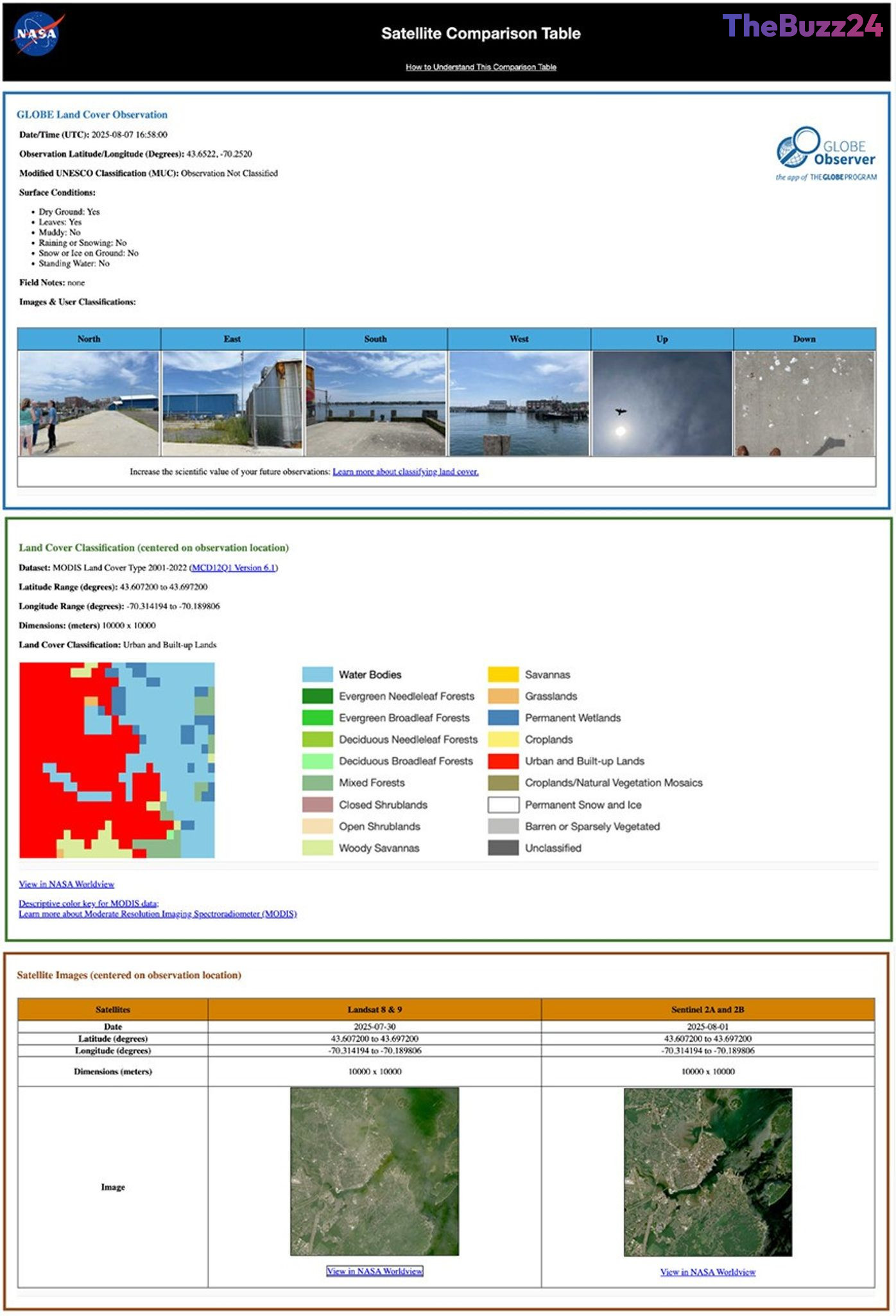
The collaboration centered on four primary objectives: refining the data collection process via the GLOBE Observer app, integrating satellite imagery into standard curricula, fostering student-led research, and validating the accuracy of ground-based observations against orbital data. By participating in this program, educators gained direct access to subject matter experts, allowing them to better understand how to utilize satellite comparison emails—which provide side-by-side data tables—to teach students about environmental changes in their local areas.
Fourteen educators participated in the program, with ten successfully developing comprehensive research plans for the upcoming 2026-2027 school year. These research projects aim to tackle critical environmental questions, such as the relationship between land cover and surface temperature, the impact of land use changes over time, and how different surface types influence local flooding patterns. Furthermore, the group contributed to the development of the GLOBE Nature Notes Guide, a resource designed to help students document their environmental observations more effectively.
This initiative highlights the growing importance of citizen science in modern education. By empowering teachers with the tools to contribute meaningful data to long-term environmental records, the program not only enhances scientific literacy but also provides students with a tangible connection to global Earth science research. Educators interested in contributing to these efforts can access the GLOBE Observer app to begin documenting environmental conditions in their own communities.
Key Takeaways
- Educators collaborated with NASA experts to integrate satellite land cover data into classroom curricula.
- The program resulted in the development of student-led research projects focusing on surface temperature, land use, and flooding.
- Participants utilized the GLOBE Observer app to contribute ground-truth data that is validated against satellite imagery from MODIS, Landsat, and Sentinel-2.
Editor’s Analysis & Impact
The GLOBE Mission Earth initiative represents a significant shift in how educational institutions leverage big data. By democratizing access to satellite imagery and providing a framework for citizen science, NASA is effectively cultivating a new generation of data-literate students. The market impact of such programs is twofold: it fosters a pipeline of future talent for the Earth observation and climate science sectors while simultaneously creating a massive, distributed network of ground-truth data collectors. As climate change continues to drive demand for granular environmental monitoring, the integration of classroom-based research with professional satellite data will likely become a standard model for environmental education. This approach not only enhances academic outcomes but also provides a scalable solution for gathering localized environmental data that would otherwise be costly or impossible to obtain through traditional research methods alone.
Frequently Asked Questions
Q: What is the GLOBE Observer app?
A: The GLOBE Observer app is a tool that allows students, educators, and citizen scientists to collect and submit environmental observations, such as land cover, to NASA for scientific research.
Q: How do educators use satellite comparison data in the classroom?
A: Educators receive a satellite comparison email after submitting observations, which includes a data table comparing their ground-based findings with satellite data from the same time and location, helping students understand how to interpret and validate remote sensing data.
AI Disclosure: This article is based on verified data and official reports. Our Team and AI have cross-referenced every financial detail with primary sources to ensure total accuracy.
More from this Category