Bridging Ancestral Wisdom and Satellite Data: Students Tackle Coastal Erosion in Maine
In the coastal community of Sipayik, Maine, students at Sipayik Elementary School are spearheading a unique environmental study that merges modern satellite technology with deep-rooted Indigenous knowledge. The project, which focuses on the accelerating rate of coastal erosion in the Passamaquoddy Bay area, aims to help younger generations understand the physical and cultural impacts of a changing shoreline. By integrating NASA satellite imagery with the oral histories of tribal elders, the students are creating a comprehensive picture of how their ancestral lands have shifted over the last century.
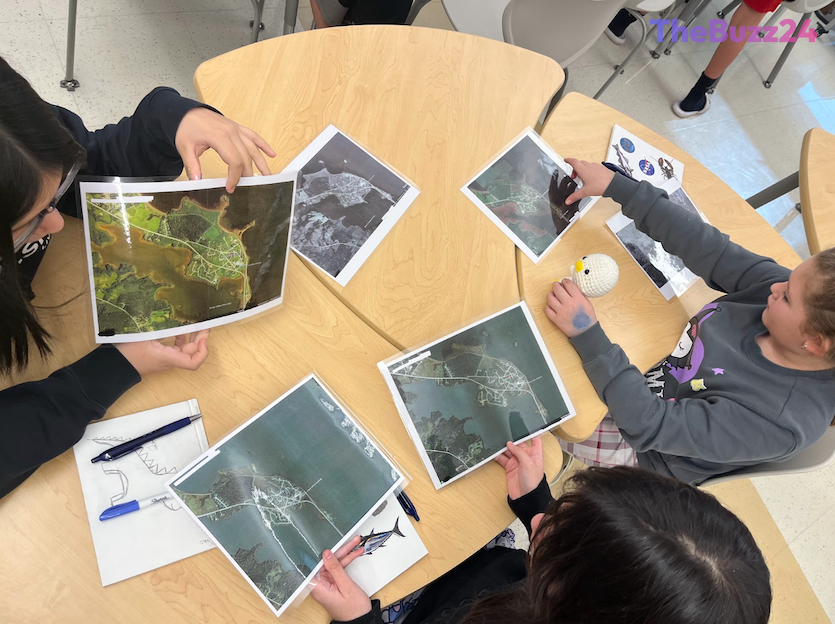
The initiative began as a collaborative effort to address the specific challenges faced by the Pleasant Point Passamaquoddy Reservation. Over a five-week period, fifth-grade students engaged in hands-on fieldwork, comparing historical tribal maps and aerial photographs dating back to 1942 with current high-tide measurements and future flood projections. This interdisciplinary approach allowed the students to see the land not just as a geographic feature, but as a repository of memory and identity that requires active stewardship.
Beyond the classroom, the students have taken their findings to the professional scientific community, presenting their research at the Gulf of Maine Research Institute. Their work has highlighted the resilience of the Passamaquoddy people and demonstrated that traditional ecological knowledge is a vital component of modern climate science. As the project looks toward the future, there are plans to expand the study to include more field sites and implement tangible resilience strategies, such as marsh restoration, in partnership with tribal leadership.
The success of this program underscores a growing movement to validate Indigenous perspectives within the scientific establishment. By empowering students to act as researchers in their own communities, the project fosters a sense of agency and environmental responsibility. The students involved have expressed a strong commitment to continuing their research, ensuring that the lessons learned from the shore remain a central part of their community’s ongoing efforts to adapt to a changing climate.
Key Takeaways
- Students in Sipayik, Maine, are combining NASA satellite data with Indigenous oral histories to track local coastal erosion.
- The project bridges the gap between Western scientific methods and traditional ecological knowledge to better understand environmental change.
- Participants are moving beyond research to plan future community resilience strategies, including potential marsh restoration efforts.
Editor’s Analysis & Impact
This initiative represents a significant shift in environmental education, moving away from purely academic models toward community-based, culturally relevant research. By validating Indigenous knowledge alongside high-tech satellite data, the project provides a scalable framework for other communities facing climate-related land loss. The broader implication is that climate resilience is most effective when it integrates local historical context with global scientific tools. As coastal erosion continues to threaten vulnerable regions worldwide, this model of ‘citizen science’—led by youth and guided by elders—offers a sustainable pathway for local adaptation. Future industry trends will likely see increased funding for such interdisciplinary projects that prioritize community-led data collection and long-term environmental stewardship over top-down policy interventions.
Frequently Asked Questions
Q: How are students using NASA technology in this project?
A: Students are utilizing NASA satellite imagery to compare current coastal conditions with historical aerial photographs and maps, allowing them to visualize and measure the rate of erosion over several decades.
Q: Why is Indigenous knowledge important to this study?
A: Indigenous knowledge provides a historical and cultural context that traditional scientific data may lack. It offers insights into how the land has changed over generations, helping students understand the emotional and identity-based impacts of land loss.
AI Disclosure: This article is based on verified data and official reports. Our Team and AI have cross-referenced every financial detail with primary sources to ensure total accuracy.
More from this Category