The Tidal Marvel of Roebuck Bay: A Coastal Ecosystem in Flux
Roebuck Bay, located in the Kimberley region of Western Australia, stands as one of the most dynamic coastal environments on the planet. Driven by the gravitational pull of the Moon, the bay experiences extreme tidal ranges that can reach up to 9 meters—a stark contrast to the 2-meter average found across much of the Australian coastline. This phenomenon is largely attributed to the region’s uniquely wide and shallow continental shelf, which amplifies incoming tides as they interact with the shore.
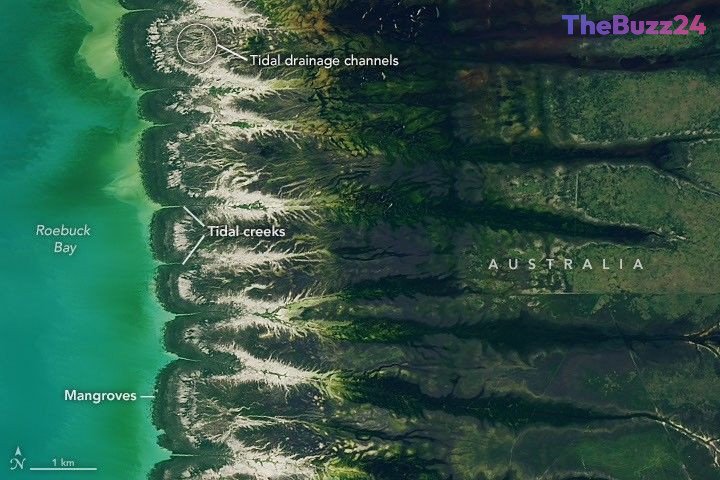
The landscape of Roebuck Bay is defined by its constant transformation. Expansive mudflats are regularly submerged and exposed, supporting a complex network of mangrove forests and tidal drainage channels. Satellite observations reveal that these mangrove forests are not static; they are expanding westward at a rate of nearly 2 meters per year, fueled by the accumulation of sediment from inland waterways. This growth is further influenced by the region’s monsoonal climate, which triggers a seasonal cycle of lush, green vegetation during the wet months and a transition to golden, arid tones during the dry season.
Beyond its geological significance, the bay serves as a vital biological hub. The nutrient-rich mudflats and mangrove nurseries provide a sanctuary for a vast array of invertebrates, including snails, crabs, and clams, which can reach densities of 2,500 per square meter. This abundance of life makes the area a critical stopover for migratory birds traveling the East Asian-Australasian Flyway. Hundreds of thousands of birds, such as godwits and knots, rely on the bay’s seasonal bounty, highlighting the delicate balance between the region’s physical geography and its ecological importance.
Key Takeaways
- Roebuck Bay experiences extreme tidal ranges of up to 9 meters, amplified by the shallow continental shelf of Western Australia.
- The region's mangrove forests are actively expanding westward by approximately 2 meters annually due to sediment accumulation.
- The bay is a globally significant ecological site, serving as a primary feeding ground for hundreds of thousands of migratory birds.
Editor’s Analysis & Impact
The study of Roebuck Bay provides critical insights into coastal geomorphology and the resilience of intertidal ecosystems in the face of climate variability. From a market and industry perspective, the data gathered from such regions is invaluable for environmental management, coastal infrastructure planning, and carbon sequestration research, as mangroves are highly efficient at storing blue carbon. The ongoing expansion of these forests suggests a robust, albeit changing, ecosystem that serves as a benchmark for monitoring sea-level rise and sediment transport. Future outlooks indicate that as global climate patterns shift, the monitoring of these ‘feathered’ drainage channels and mudflat health will become increasingly important for conservationists and policymakers aiming to protect biodiversity hotspots that are essential to global migratory bird populations.
Frequently Asked Questions
Q: Why does Roebuck Bay have such extreme tides?
A: The extreme tidal range is primarily caused by the exceptionally wide and shallow continental shelf off the coast of northwestern Australia, which amplifies the tidal energy as it moves toward the shore.
Q: What makes Roebuck Bay important for wildlife?
A: It is a critical stopover on the East Asian-Australasian Flyway, providing essential food sources for hundreds of thousands of migratory birds, while its mangrove forests act as nurseries for various fish and crustacean species.
AI Disclosure: This article is based on verified data and official reports. Our Team and AI have cross-referenced every financial detail with primary sources to ensure total accuracy.
More from this Category