Catastrophic Super Typhoon Bavi Threatens Guam and Northern Mariana Islands with Devastating Winds
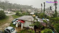
Emergency preparations are underway across the US Pacific territories of Guam and the Northern Mariana Islands as Super Typhoon Bavi, a monstrous storm carrying sustained winds of up to 257 km/h (160 mph), barrels toward the region. Meteorological authorities have warned of potentially catastrophic damage, torrential rains, and massive waves reaching up to 11 meters (35 feet) as the storm makes its projected landfall. Residents and local businesses are racing against time to secure properties and evacuate vulnerable areas before conditions deteriorate.
In response to the imminent threat, local officials in Guam have established emergency shelters in public schools to accommodate vulnerable populations. However, demand has already pushed some of these facilities to maximum capacity, forcing authorities to redirect evacuees to alternative sites. The storm’s destructive outer bands are expected to lash the islands hours before the eye makes direct contact, leaving a rapidly closing window for residents to seek safe shelter. Local business owners, already struggling under economic pressures, have been boarding up storefronts, while tourists face disrupted travel plans due to widespread flight cancellations.
Classified as a super typhoon, Bavi is the equivalent of a Category 4 or 5 hurricane, capable of causing widespread devastation to infrastructure and power grids. This extreme weather event highlights a worrying trend in the western Pacific, where rising sea surface temperatures and a strong El Niño pattern are fueling increasingly intense storms. Bavi marks the eleventh Category 4 or 5 tropical cyclone to threaten US territories within the last decade, a stark increase compared to historical averages. This follows the devastating impact of Typhoon Sinlaku earlier this year, which resulted in significant casualties and billions of dollars in damage, underscoring the region’s growing vulnerability to severe weather anomalies.
Key Takeaways
- Super Typhoon Bavi is projected to make landfall in Guam and the Northern Mariana Islands with catastrophic winds of up to 257 km/h (160 mph).
- Emergency shelters have been opened across Guam, with some already reaching maximum capacity as residents seek refuge from life-threatening storm surges and flooding.
- The storm represents a growing trend of high-intensity tropical cyclones in the Pacific, exacerbated by rising sea temperatures and El Niño conditions.
Editor’s Analysis & Impact
The impending strike of Super Typhoon Bavi on Guam and the Northern Mariana Islands underscores the escalating economic and infrastructural risks faced by Pacific island communities. Beyond the immediate threat to human life, such extreme weather events inflict severe long-term damage on local economies, particularly tourism and small businesses, which are already operating on thin margins. From an insurance and global climate perspective, the increasing frequency of Category 4 and 5 storms—driven by rising sea temperatures and El Niño cycles—will likely lead to soaring insurance premiums, stricter building codes, and a pressing need for substantial federal disaster mitigation funding. For industries relying on Pacific shipping routes and regional military infrastructure, these supercharged typhoons present persistent operational challenges, signaling that climate resilience must transition from a long-term policy goal to an immediate infrastructure priority.
Frequently Asked Questions
Q: What makes Bavi a 'super typhoon'?
A: A super typhoon is a tropical cyclone that reaches sustained wind speeds of at least 150 mph (130 knots), which is equivalent to a strong Category 4 or Category 5 hurricane on the Saffir-Simpson scale.
Q: How are local authorities in Guam preparing for the storm?
A: Local officials have opened multiple emergency evacuation shelters in public schools to protect vulnerable residents, issued urgent evacuation warnings, and advised everyone to secure their homes and remain indoors as the storm approaches.
Q: Why are intense typhoons becoming more common in this region?
A: Scientists attribute the rising frequency and intensity of these powerful storms to climate change, which warms sea surface temperatures and injects more moisture into the atmosphere, alongside weather patterns like El Niño that supercharge tropical cyclones.
AI Disclosure: This article is based on verified data and official reports. Our Team and AI have cross-referenced every financial detail with primary sources to ensure total accuracy.
More from this Category