Record-Breaking April Super Typhoon Sinlaku Challenges Meteorological Norms
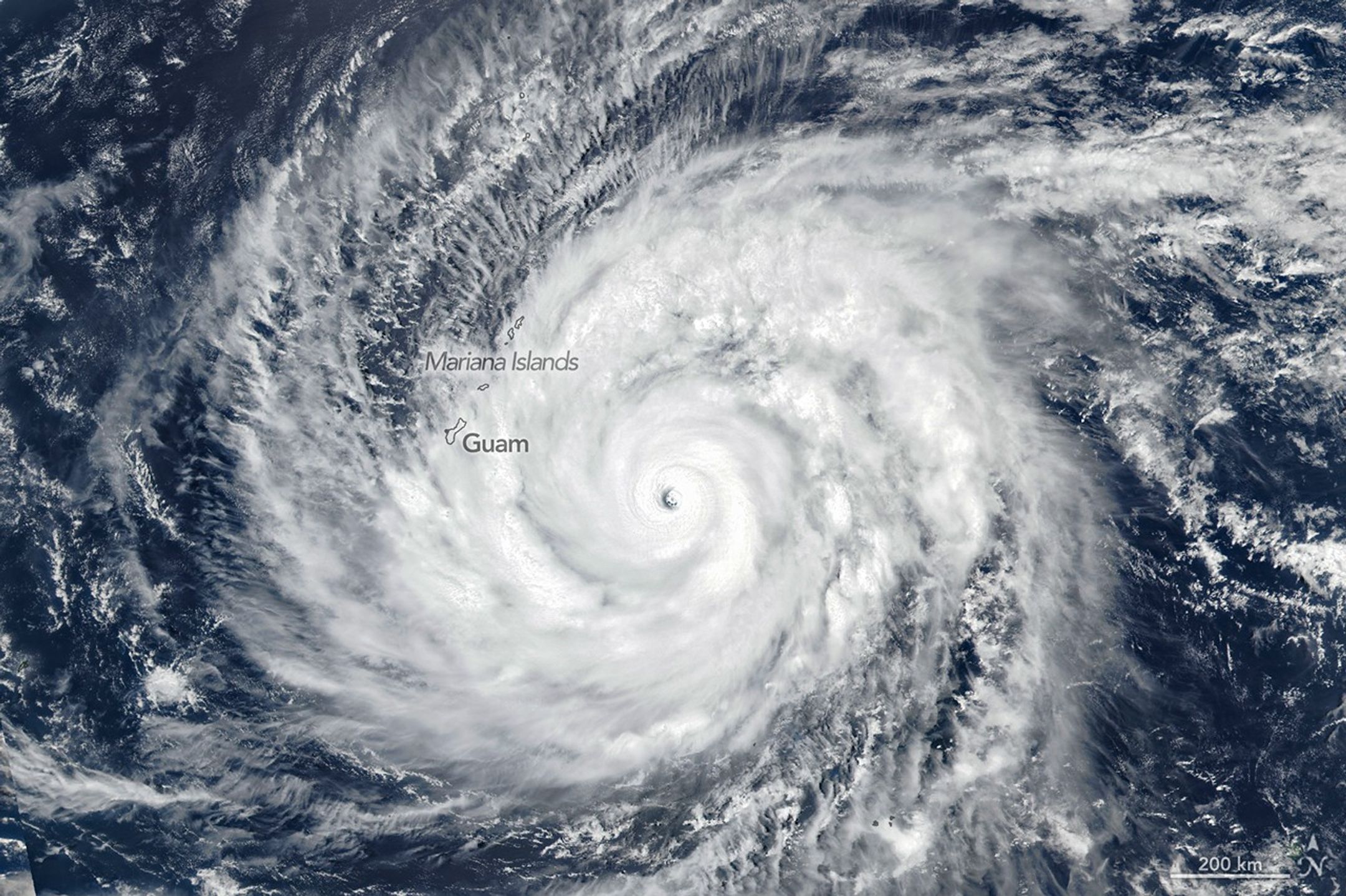
A rare and exceptionally powerful weather event has gripped the North Pacific, as Super Typhoon Sinlaku underwent a period of rapid intensification that shattered historical records for the early spring season. By April 13, satellite data confirmed that the storm had reached Category 5 status, boasting sustained wind speeds of 280 kilometers per hour. This level of intensity is virtually unprecedented for the Northwestern Pacific basin during the month of April, marking a significant deviation from typical seasonal weather patterns.
The storm’s trajectory brought its destructive outer bands directly over the Mariana Islands, including Saipan, Tinian, and Rota. In response, local authorities enacted emergency protocols, urging residents to prepare for hurricane-force winds and catastrophic rainfall. While the system was projected to maintain its peak intensity only briefly before weakening into a tropical storm, the immediate threat to the islands necessitated urgent disaster management efforts.
Beyond the immediate impact on the islands, Sinlaku has become a focal point for atmospheric research. The storm generated powerful gravity waves that penetrated deep into the mesosphere, creating rare visual phenomena in the night sky that have captivated the scientific community. The emergence of such a violent system so early in the year underscores a growing trend of unpredictability in global weather patterns, prompting experts to re-evaluate existing models for tropical cyclone development in the Pacific.
Key Takeaways
- Super Typhoon Sinlaku reached Category 5 intensity in mid-April, an extremely rare occurrence for the Northwestern Pacific.
- The storm caused significant concern for the Mariana Islands, triggering emergency protocols due to high winds and heavy rain.
- Atmospheric scientists are studying the storm's unique gravity waves, which reached the mesosphere and created rare visual patterns.
Editor’s Analysis & Impact
The emergence of a Category 5 typhoon in April serves as a sobering indicator of shifting climate dynamics. Historically, tropical cyclone activity in the Northwestern Pacific follows a predictable seasonal cadence; however, the rapid intensification of Sinlaku suggests that ocean heat content and atmospheric conditions are becoming increasingly conducive to extreme weather events outside of traditional windows. For the insurance, shipping, and disaster management sectors, this shift necessitates a fundamental reassessment of risk models. If early-season super typhoons become a recurring phenomenon, regional infrastructure and emergency response frameworks will require significant upgrades to handle the increased frequency of high-intensity storms. This event highlights the urgent need for more robust, real-time meteorological monitoring and a global commitment to understanding the long-term implications of these anomalous weather patterns on regional stability.
Frequently Asked Questions
Q: Why is Super Typhoon Sinlaku considered unusual?
A: It is considered unusual because it reached Category 5 intensity in mid-April, which is historically rare for the Northwestern Pacific basin during the early spring.
Q: What specific scientific phenomenon did the storm produce?
A: The storm generated intense gravity waves that reached deep into the mesosphere, resulting in rare and distinct visual patterns in the night sky.
AI Disclosure: This article is based on verified data and official reports. Our AI have cross-referenced every financial detail with primary sources to ensure total accuracy.
More from this Category